Civilytics AI reads engineering site plan PDFs, classifies every element by category, and checks them against zoning code in seconds.
Every element classified, every setback measured live in your browser.
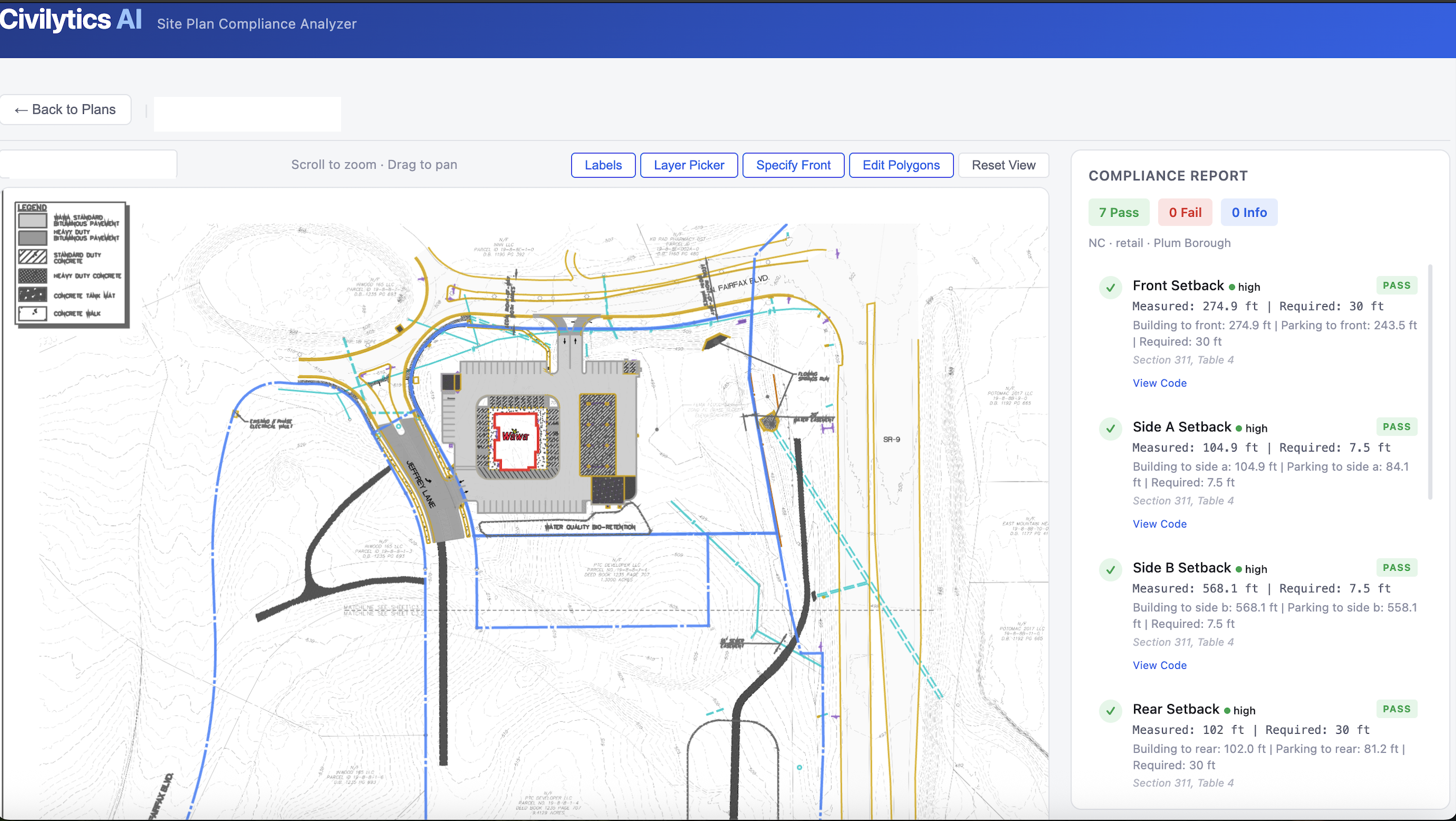
Our HGNN model was trained on real plan submissions and learns to classify geometry even when CAD layer data is absent. Property lines, buildings, parking, setbacks: identified from the lines themselves, not just metadata.
Civilytics ingests the full zoning ordinance for each jurisdiction: setbacks, lot coverage limits, parking ratios, and more. Every check applies the exact local requirement. No approximations. No assumptions.
What takes a reviewer hours to verify manually, Civilytics completes in seconds: measuring setbacks, counting stalls, computing coverage. Your team stays focused on the decisions that require judgment.
No manual takeoffs. No guessing. Civilytics reads the plan the way a trained engineer would but in seconds.
Drop in any CAD-exported PDF. The app reads every line, curve, and shape on the plan and prepares them for classification.
Every line, curve, and shape is classified by type: property lines, buildings, parking, setbacks, utilities, grading, and more. Classification uses a hierarchical model trained on real engineering plan submissions.
The app reads the title block and scale bar to convert PDF coordinates into real-world feet, then measures every relevant distance automatically.
Pass/fail results for setbacks, lot coverage, parking counts, and more streamed live as each check completes, with the plan highlighted in the viewer.
Built for the real workflow of municipal engineers and development teams.
Every element drawn and color-coded by class. Pan, zoom, isolate categories, and click to identify any element on the plan.
Front, side, and rear setbacks measured automatically from property lines to building footprints using real-world scale.
Detects individual parking stalls and compares required vs. provided counts based on land use and square footage.
Computes building footprint area as a percentage of total lot area and checks against your zoning district's maximum.
Select a folder of zip files or PDFs the app auto-discovers all valid site plans and imports them in one click.
Re-analyzing the same plan with the same district returns results instantly no re-processing needed.
Flag non-compliant submissions before they enter the queue. Cut back-and-forth with applicants.
Self-check plans before submission to avoid costly revision cycles and permit delays.
Run a compliance pass on your own drawings as a QC step before delivering to clients.
Compare a site plan against multiple zoning districts to identify the best path to approval.
Screen a portfolio of potential sites against local zoning rules in minutes, not hours.
Catch dimensional issues in submitted plans before breaking ground.
Civilytics AI was founded to eliminate the manual, error-prone process of checking engineering site plans against zoning code. We combine deep domain expertise in land development with cutting-edge AI to make plan review faster, more consistent, and less costly for everyone involved.
Drop your email and we'll reach out to schedule a live walkthrough using your actual site plans.
We'll walk you through the full workflow upload a plan, run a compliance check, and see results live tailored to your zoning district and use case.
No commitment required. We typically respond within 1 business day.